Page 1 of 1
Mapping Project: Northern Gun (Version 1.1 DONE)
Posted: Sun Dec 01, 2013 11:47 pm
by Hotrod
I've been kicking around some ideas for a Northern Gun map for a while now. Most of my maps to date have either been for Palladium Fantasy or my novel manuscript project. This is my first foray into doing a publish-able Rifts map.
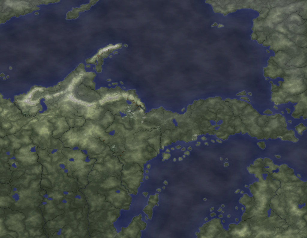
I took a rough hack at it a couple of weeks ago. It's bare terrain, but
I thought some folks here might like it, so I uploaded it on my DeviantArt page. The coastlines and lakes are fairly close, but I was working off a photo of the maps in NG1, not a good-quality scan, so there are some minor warping issues. Also, note that the topography and rivers in this map are totally random. Though I can sculpt the randomized terrain with the techniques I use, this was a rough draft intended to give me an early look of how such a map could look as a finished product.
My current effort is a zoomed-in Upper Peninsula map (with far more detail and definition than what you see in NG1's interior maps) with a more-detailed shoreline. This will allow me to pack in as much local information as I can into the map.
So anyway, I hope you like the freebie map. If you have any ideas or requests for this map in particular or my mapping techniques in general, please reply here or pop me a PM.
Re: Northern Gun Map Project (Free draft)
Posted: Mon Dec 02, 2013 10:27 am
by jaymz
cool

Re: Northern Gun Map Project (Free draft)
Posted: Mon Dec 02, 2013 12:03 pm
by nilgravity
Nice I added you to my watch
Re: Northern Gun Map Project (Free draft)
Posted: Fri Dec 06, 2013 2:04 pm
by Hotrod
I've hit a snag: The Mantistique Imperium. Other than Mantistique's location, a highway, and a few lakes, NG1 doesn't have much to say or show about that part of the Upper Peninsula. It does mention that there are a number of city-states, of which Mantistique is the largest, but they're not mapped or described.
Are they mentioned in any other supplements, or do I just have to wait for NG2 to come out?
In any case, I've mapped out the physical topography now, with canon-consistent rivers and elevations. I've also worked in some urban textures sized according to each location's description in NG1. Now I'm playing with color gradients and climate zones.
Re: Northern Gun Map Project (Free draft)
Posted: Thu Dec 19, 2013 11:00 am
by Hotrod
I have two versions of the map drafted now.
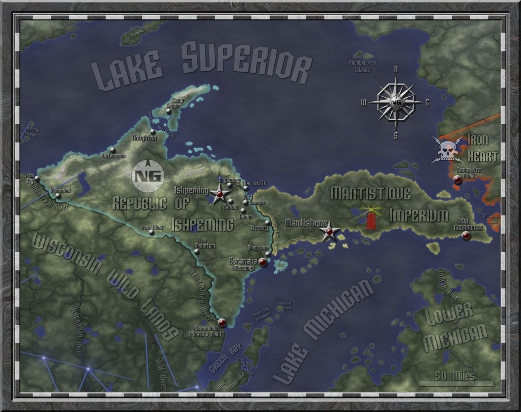
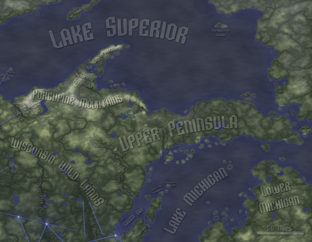
The first is all about natural geography. The labels are as transparent as I can make them (while at the same time keeping them legible), and they mark rivers, lakes, iron deposits, the Porcupine Mountains, and the wider regions (Upper peninsula, Lower Michigan, Wisconsin Wild Lands). Cities appear in this one, but you have to look closely, because they're just textures that I've airbrushed in at the right places. I've also airbrushed in a dozen open-pit mines at the appropriate places for the three major iron ore deposits in the UP (the bulk of them are in the Marquette Range, since that's the safer/more-developed area). This map is in pretty good shape overall.
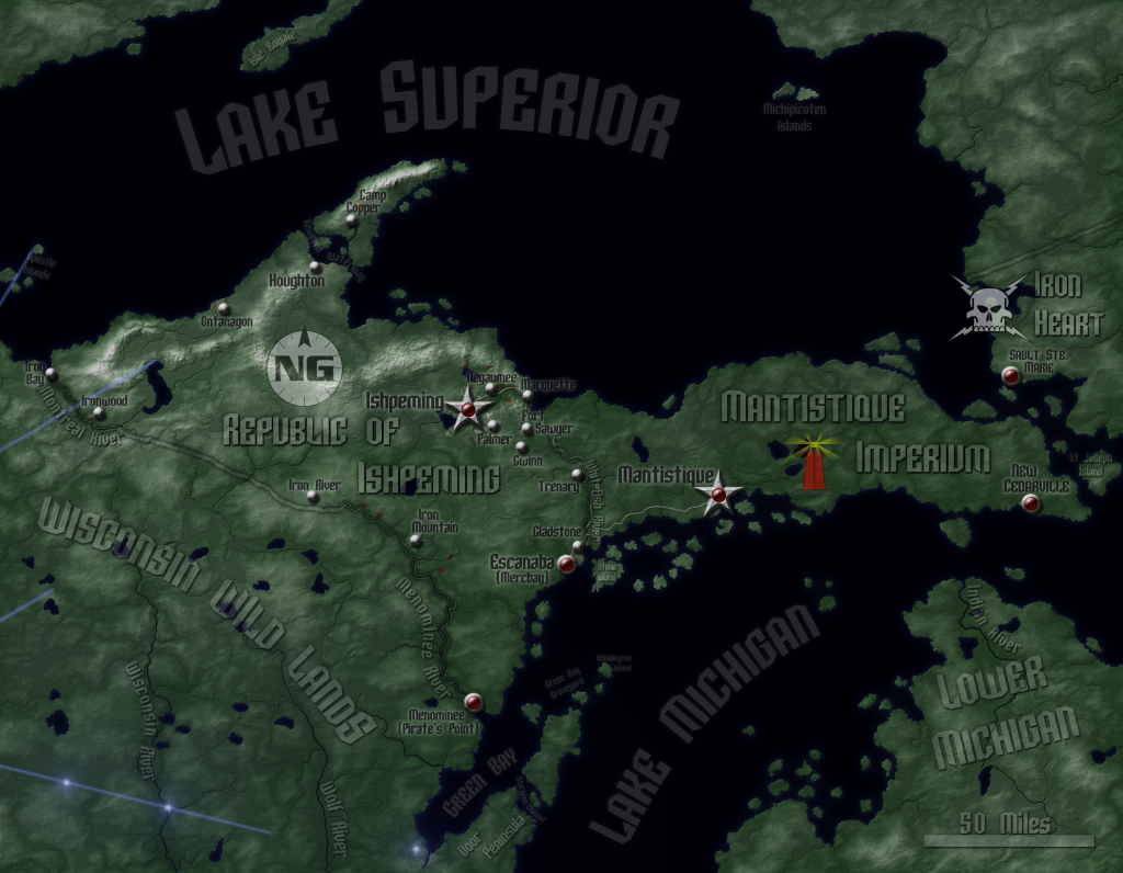
The second is all about political geography. It shows borders and has city icons that look like physical objects placed on the map. All towns and forts are marked and labeled (Including New Cedarville, the home of Titan Robotics, which I pulled from Aftermath and placed according to Cederville's present-day location), as well as the M.I. highway. I've also included the logos for the C.S. (for the portion of Iron Heart that appears), NG (for the Republic of Ishpeming), and I custom-made one for the Mantistique Imperium (based on their famous red lighthouse). In regions where there aren't settlements, I kept the natural geography labels.
I have some revising yet to do on the political map. I need to scour my Rifts library to see if there are any settlements in the UP, Wisconsin or Lower Michigan that don't show up in NG. So far, the only one I've come across is New Cedarville.
I have one more version I want to try, and it requires an approach I haven't yet taken: a supernatural overlay. Ley lines, nexuses, and major threat areas. I have some ideas on how to to ley lines (light blue, low opacity, fade the edges, and de-color the ground it lies on), and I can use the nova effect in GIMP for nexuses, but I'm not so sure how to depict threat regions. I've got some brain-storming to do there.
Re: Northern Gun Map Project (Free draft)
Posted: Tue Apr 01, 2014 4:02 pm
by Hotrod
EDIT: This post is mostly deleted. Don't worry, you aren't missing anything, just me whining about my own indecisiveness and trying to leave it to you guys to make my own tricky artistic decisions. I'm leaving the in-progress link up.
Here's the current master draft, in which I try to include as much as I possibly can. (Note: the actual image size is larger than this, but Photobucket won't allow a 3300x2600 map to show up in all its glory. It shows enough for you to get the idea, but some of the smaller labels are a little hard to read)
Re: Mapping Project: Northern Gun (topography/icons/labels d
Posted: Sun Apr 27, 2014 10:31 pm
by Hotrod
The Northern Gun Map project is back!
Now that the Atlantis map is done, this map is getting my full attention again.
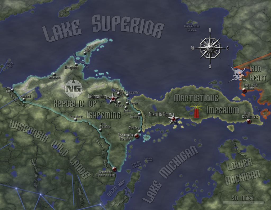
Here is the current version of the map. Here is a bare-topography version (though you can see cities embedded into the image if you look closely).
Features of this map:+All map data from the NG1 maps is included, as well as several additional features from the text of NG1. There are a number of features from canon text, canon maps in other books, and real-life map information.
+You can actually see the cities on this map. The scale is small enough that the land area of the settlements isn't something that can be totally hidden behind icons, so I experimented with airbrushing in some city textures I yanked from free satellite imagery.
+All canon settlements that are inside the map are marked (I think, please check me on this). I included New Cedarville, which is described in Aftermath, but is not marked in NG1. It's placed in about the same spot as present-day Cedarville.
+I re-created the CS and Northern Gun logos in vector to mark the countries of Ishpeming and Iron Heart, respectively. The lighthouse logo of Mantistique is my own creation, based on some famous lighthouse that exists in present-day Mantistique (it was featured on the city webpage, and it seemed a good metaphor for a peninsula country that has survived the apocalypse).
+New city icons, custom-made for this map. They seem a bit less metallic than what I was going for, but I'm satisfied with them.
+A dozen iron mines are visible, though they're not marked. They are placed according to the actual real-life iron deposits in the region. I have a version of the map that labels these deposits.
Changes:+I re-worked all the coastlines to make them a bit choppier up close. The islands were too blob-like in the previous version. I also re-worked the rivers and fixed a few minor issues with a couple of minor rivers running close and parallel to the coast in a couple of places.
+I added ley lines to justify the nexus points listed by location in RUE and Aftermath, since it seems rather silly to have canon nexus points mapped without any ley lines. I used the magic zone shown on GMG page 333 as a guideline.
+I added texture to the water. This is cosmetic only, and does not reflect any bathymetry (underwater topography)
+I made the settlement icons solid, like the settlements they name. They didn't quite turn out as steel-ish as I wanted, but they match the icons well enough.
Issues with the map:-I don't own any Rifters, so any map-worthy official material from them isn't included.
-The "city" icon may be mis-assigned in a couple of places. In this map, it is associated with cities with populations of at least 50,000. I have no information on Sault Ste. Marie; it may or may not qualify. Given its strategic location, it seems appropriate that it be a city.
-Xiticix territory is not marked. They only control the extreme northwest corner of the map, so I felt this was justified. However, if they control Isle Royale, I may need to include a bug-head icon. I can't find any info on their precise territory boundaries regarding Lake Superior.
-There's no bathymetry (underwater topography). I may try to fix this later.
-Many islands are un-marked. If I'm not sure of their names, I leave them nameless.
Still to do:1. Create a frame. I'm going to try something metallic this time to go with the heavy metal theme of Northern Gun.
2. Create a Compass Rose and Legend.
3. Adjust the water effects to indicate the deep spots on the map in Lake Superior and Lake Michigan (but only if I can make it look good).
4. Balance and optimize colors and other little things.
5. Create a "natural geography" version. I had to cut a number of natural geography labels to make way for the political labels in this map.
6. I'd like to revise the national borders with a different technique that should be clearer and better-looking.
Re: Mapping Project: Northern Gun (80% Done)
Posted: Sun Apr 27, 2014 11:36 pm
by BuzzardB
I love this and the Atlantis map, whats else you planning to do in the future?
Re: Mapping Project: Northern Gun (80% Done)
Posted: Mon Apr 28, 2014 12:09 am
by Hotrod
I'm glad you like both maps. I'm not sure what my next project will be. I'm planning on doing a couple more pieces and then submitting a portfolio to Palladium. After that, it's all up to Kevin. In any case, I have 2-3 more maps to make, as Palladium requires 12 original works for an unsolicited art submission. I could always throw in some of my less-refined works, like my Lego Space Marine or a collection of icons I've made, but I'd rather have those be fun little extras.
Unless someone commissions me to make a particular map, I'm open to suggestions. I'll probably do a PFRPG or Rifts regional map next, or maybe one of each. I might try my hand at an urban map, with something very small-scale, like a village, small town/castle, or something with no more than a few dozen buildings, not like Chi-Town (*shudder*).
Re: Mapping Project: Northern Gun (80% Done)
Posted: Tue Apr 29, 2014 7:16 am
by Hotrod
Status: I did some more tweaking last night.
Here is the current state of the map.Changes:
+I made a new compass rose for this map. I went for a more angular look with the ring, and I used the NG logo as the central symbol.
+I re-balanced some of the water effects and lightened the water. I still need to look at ways to suggest the bathymetry.
+I added some color effects to the national borders.Next step is the frame and legend.
Re: Mapping Project: Northern Gun (80% Done)
Posted: Thu May 01, 2014 11:28 am
by CyCo
Looks Awesome! 8]
Re: Mapping Project: Northern Gun (80% Done)
Posted: Thu May 01, 2014 3:19 pm
by Pepsi Jedi
Just a note, you might want to move Gwinn and Sawyer a bit further south. Your map has Sawyer almost on the coast, in reality we're 35 miles away and over a mountain. I know map distances can be a bit deceiving but yeah, your dot for the base is almost right on the coast.
Takes us 30-35 minutes to drive it on a good day doing 60mph+
Gwinn's also alot closer to Sawyer than Sawyer or Gwinn are to the coast.

Re: Mapping Project: Northern Gun (80% Done)
Posted: Thu May 01, 2014 4:17 pm
by Hotrod
See, this is why I like posting in-progress shots. It's easy to miss the details, and a pain to clean them up once I'm done. I've never been to the UP myself, just the lower "hand" and Wisconsin.
Your point is well-taken.
Here's the map with a scan I have of one of NG1's maps superimposed. Both Gwinn and Fort Sawyer are slightly out of place. I'm not sure why I deviated there, but I'll adjust. Comparing them with Google Earth, it looks like the canon map shifted both cities north slightly as well. I may shift them a touch more south than even the canon map indicates and compromise between reality and canon..
Re: Mapping Project: Northern Gun (80% Done)
Posted: Thu May 01, 2014 6:43 pm
by Pepsi Jedi
No worries.
Just trying to help out.
Been living here in the center of NG for over a decade now.
Re: Mapping Project: Northern Gun (80% Done)
Posted: Thu May 01, 2014 9:12 pm
by dragonfett
I used to live in the bottom left (southwest) corner of the hand myself. Exit 16 on I-94.
Re: Mapping Project: Northern Gun (80% Done)
Posted: Thu May 01, 2014 10:48 pm
by Hotrod
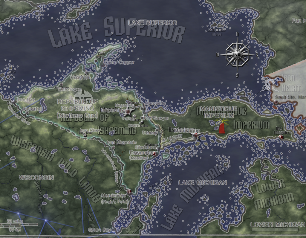
Status: All functional parts of the map are placed.
Here is a copy of the current draft. Also, here is a natural geography version. No fancy icons here; you can see the terrain in all its glory, and without the political labels, there's room for more natural geography labels, like the Porcupine Mountains and the iron deposits.
Changes:+I added in a frame and a legend. I decided on a solid metal look. Since plain steel is visually a bit boring, and scratched/tarnished steel doesn't match the look of the map, I came up with a way of drawing damascus/pattern welded steel with some distortion tools.
+Gwinn and Fort Sawyer have moved south, closer to their real-life locations. I also moved the city textures with them, though the icons obscure almost all of them.
+I added a scale. The neat lines (checkered stripes along the edge) come out nicely to 4 stripes = 50 miles = 80 kilometers.
The compass rose, scale, and legend are clustered together for now; I'm thinking about spreading them out. I'm still contemplating including some bathymetry. I'm going to give this a few days before I do my final tweaking. In the meantime, I welcome your suggestions on how to tweak and finish this map.
Re: Mapping Project: Northern Gun (99% Done)
Posted: Tue May 06, 2014 6:19 pm
by Hotrod
The map project is complete.
Here's the final version. You'll probably have to click on the image once or twice to see it in full resolution.
Version notes:
+I re-did the borders to fix a few minor discrepancies that showed up when I revised the coastlines and rivers earlier.
+I added in a bit of shading to the water to suggest the underlying bathymetry. The darker places are places of real-life deep spots in Lake Michigan and Lake Superior.
+I made some adjustments to the labels on the Natural Geography map, increasing the size of the Marquette Range label and re-balancing all the labels to bring them out more.
+I moved the legend and compass rose so they won't block part of Lake Superior's eastern shore.
+I made several minor tweaks to the map to the city labels, rivers, and the frame.
So that's it. Barring any glaring errors that someone else may find, the NG map is done. Enjoy!
Re: Mapping Project: Northern Gun (100% DONE)
Posted: Wed May 07, 2014 12:37 pm
by Balabanto
My god! They need to hire you and pay you for this. Because if this was a published, print product, I would buy it at double whatever the value is. The random calculating of distances, the guesswork, it's a fricking nightmare.
Rifts would be three times the game if it had maps to equal the fluff. Please, Kevin, pay this man some money and get this done.
Re: Mapping Project: Northern Gun (100% DONE)
Posted: Wed May 07, 2014 2:55 pm
by Hotrod
Drawing these maps soaks up a lot of time, and much of it is due to the fact that I keep everything as canon-accurate as possible. Palladium's published maps tend to be hand-drawn affairs meant to complement specific ideas in the corresponding text. There are occasional clashes with other published maps and written material, sometimes in the same book. As an example, the two maps in NG1 do not line up with each other, no matter how I scale, turn, grow, and shrink them. One map has a wider peninsula (north-south) than the other, and the islands aren't quite in the same relative spots. That's not a dig at Palladium; their maps simply aren't meant for what I'm trying to do. That said, these maps probably take 2-3 times more work than an original map would take me. Of course, it's really fun for me, so I don't see it as work.
Unless Kevin decides to pick me up as an artist, it can't be compensated work anyway. I can't in good conscience sell any prints, as these are derivative works. However, I've posted them at full resolution on DeviantArt. As long as you don't go selling them, you're welcome to print and use them. I haven't tried printing most of them, and be warned that you may need to adjust the file with some brightness/contrast to make it print well, as printed images tend to be far darker than their screen files. If there's significant demand for it, I may try optimizing these maps for print myself.
Both versions of the Atlantis and NG maps will print best on 8.5x11 at 300dpi. They will require a bit of cropping to fit, since I designed these maps to have some wiggle room for fitting onto a page. Alternately, if you want to keep the frames and every single pixel of definition, you could print them as photos/posters at Walmart or some other print shop. This can get expensive, though, and be careful not to succumb to the temptation to get a gigantic print; these are bitmap images, and they start getting pixelish when you get under 200 dpi.
My favorite way to look at them is on my flatscreen TV at home, but
unless you have an epic RPG setup like this guy, it may be impractical to display them digitally at a tabletop gaming session. If you game by Skype, that's a different story.
Anyway, thanks for the kind words. I'm thinking one or two maps, and then I'll send in an unsolicited artist portfolio and see what the man thinks. In the meantime, consider this a global bonus of the NG book kickstarters that's free for everyone.
Re: Mapping Project: Northern Gun (100% DONE)
Posted: Thu May 08, 2014 5:41 am
by cl7277
If you keep making maps this cool, I would love to have a book just of maps. It would really help out. Love this map keep up the great work. And also, I hope that Palladium and your self can come to some sort of deal, to get this and your other maps into print.
Re: Mapping Project: Northern Gun (100% DONE)
Posted: Thu May 08, 2014 9:10 pm
by FluidicAztec
Your work is awesome...I could easily see KS selling these individually as PDF and in the store as high quality prints. A long term goal would be different regional atlas compendiums. Thanks for all the super cool work. If you get froggy, Rifts Russia would be cool with all the different Warlords...
Re: Mapping Project: Northern Gun (100% DONE)
Posted: Thu May 08, 2014 10:34 pm
by Hotrod
Russia would be a big project. Lots of rivers, mountains, neighboring regions, and a whole lot of interior border work. It's doable.
I'm not sure what I'm going to do next; I may do a Palladium Fantasy one.
Re: Mapping Project: Northern Gun (100% DONE)
Posted: Thu Nov 19, 2015 1:01 am
by NMI
Thread unlocked.
Original Topic Starter given permission to add to the topic.
Re: Mapping Project: Northern Gun (100% DONE)
Posted: Thu Nov 19, 2015 1:19 am
by Hotrod
Thanks, NMI!
I just wanted to follow up on this thread, especially since several posts specifically asked about this. Some high-quality prints of this map will be available upon request for this year's Christmas Surprise Packages.
Re: Mapping Project: Northern Gun (100% DONE)
Posted: Thu Nov 19, 2015 1:21 am
by Alrik Vas
awesomesauce.
Re: Mapping Project: Northern Gun (100% DONE)
Posted: Wed Aug 24, 2016 7:06 am
by Hotrod
So I got a copy of Mercenaries a couple weeks ago, and as I read it over, I came across the fact that Wellington (where Wellington Industries gets its name) is in the Manistique Imperium (which I misspelled with an extra t in this map). I think it's time for a revision that adds in this important city to the map and fix my bad spelling.
Here's my problem: I can't find any town or city named "Wellington" in the upper peninsula in the canon maps or in modern maps. There's a Wellington Township in Michigan, but it's in the hand-part of the state (by the forefinger's tip). Anyone know of a Wellington in the UP? Or a canon location for the city? If not, no biggie, I'll just make an educated guess.
Re: Mapping Project: Northern Gun (100% DONE)
Posted: Wed Aug 24, 2016 2:49 pm
by Marcethus
I can't answer your question but I do want to say that your map is excellent work.
Re: Mapping Project: Northern Gun (100% DONE)
Posted: Thu Aug 25, 2016 8:21 am
by ShadowLogan
Hotrod wrote:So I got a copy of Mercenaries a couple weeks ago, and as I read it over, I came across the fact that Wellington (where Wellington Industries gets its name) is in the Manistique Imperium (which I misspelled with an extra t in this map). I think it's time for a revision that adds in this important city to the map and fix my bad spelling.
Here's my problem: I can't find any town or city named "Wellington" in the upper peninsula in the canon maps or in modern maps. There's a Wellington Township in Michigan, but it's in the hand-part of the state (by the forefinger's tip). Anyone know of a Wellington in the UP? Or a canon location for the city? If not, no biggie, I'll just make an educated guess.
It is possible that "Wellington" is a post-PA name and not a pre-Rifts hold over given the statement that Wellington seems to be based on a "pre-rifts weapons manufacturing complex" (Mercenaries pg102) that is almost assuredly a Golden Age development (possibly late) for whatever community the complex was near. RUE doesn't mention the city at all (company yes), and not likely mentioned in RMB (I did try Canada, but no dice other than a generic marker for NG and MI). This likely means Wellington is one of those "where ever you want in w/n the Imperium's boarders" situation at present.
Unless you can find something to point toward it being the RW Wellington, or find what could be considered a "weapons manufacturing complex" in the eastern portion (which is what Rifts Canada implies is the Imperium's holdings, with NG on the central part).
Re: Mapping Project: Northern Gun (100% DONE)
Posted: Thu Aug 25, 2016 8:59 am
by Hotrod
Yeah, between the lack of significant present-day military presence and the fact that the UP is mostly about mining and agriculture, not manufacturing these days, I've picked a spot by a river mouth opening into a natural harbor.
Here is version 1.1, now with Wellington and a properly-spelled Mantistique Imperium!
Of course, with as many canon sources as there are about this region, any change like adding a city can introduce new canon conflicts. There are canon sources stating that there are only a couple of big cities in MI, and I now have three, but all three are specifically mentioned as being cities, so I'm ok with this.
Re: Mapping Project: Northern Gun (Version 1.1 DONE)
Posted: Thu Aug 25, 2016 5:18 pm
by J_cobbers
I didn't realize it on the political map, but once I saw the 'plain' geography, I realized you even included the basic city terrain for each major city. Are those details you made up or did you pull them from maps in the NG books? Either way, wow, that's some crazy detail!
Re: Mapping Project: Northern Gun (Version 1.1 DONE)
Posted: Thu Aug 25, 2016 7:16 pm
by Hotrod
J_cobbers wrote:I didn't realize it on the political map, but once I saw the 'plain' geography, I realized you even included the basic city terrain for each major city. Are those details you made up or did you pull them from maps in the NG books? Either way, wow, that's some crazy detail!
Thanks for noticing! The city terrain is from urban aerial and satellite photography that I scaled and blended in. I placed them deliberately to match up to the cities and activities described in the book. I also blended in some open pit mines in areas where the book mentions iron mining. I also looked up the actual iron deposits on real-life maps to get the locations right. These areas look dark red-ish, similar to how they look in real life in that area (there are some open pit mines around Ishpeming that I looked at on Google Earth).
I don't usually put that kind of physical detail into my maps, since they're generally obscured by the city icons I put in (as they are in the political version) but the scale and the canon details made it possible, and this map was a labor of love. Anyway, I appreciate the kind words!